


The summertime low-oxygen “dead zone” in the Gulf of Mexico -- a killer of bottom-living organisms and threat to commercial shrimp and other fisheries -- is forecast to cover about 4,155 square miles along the Louisiana and Texas coasts this year, or more than six Lake Pontchartrains.
That amounts to about 1,200 square miles smaller than the average during the 36-year history of dead zone measurements in the Gulf, NOAA announced Monday, but still more than twice as large as the long-term hypoxia-reduction goal set by a federal-state task force.
This year's forecast would be about 1,000 square miles larger than what was actually measured last year.
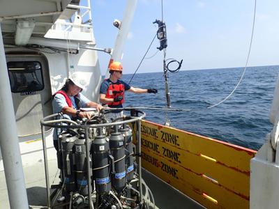
Scientists from Louisiana State University, the Louisiana Universities Marine Consortium, NOAA and other universities will travel along the coasts of Louisiana and Texas during the last week of July and first week of August to see if the estimate holds up.
But LSU marine biologist Nancy Rabalais, who has overseen the dead zone mapping cruises since they began in 1985, said there’s a good chance that the estimate could be high for a second year in a row, and for the same reason: Less rainfall in the Midwest is expected to again keep the flow of the Mississippi and Atchafalaya rivers’ freshwater below normal levels well into the summer.

The Mississippi River watershed, which encompasses over 40% of the continental U.S and crosses 22 state boundaries, is made up of farms (yellow), cities (red), and natural lands (green). Nitrogen and phosphorus pollution in runoff and discharges from agricultural and urban areas are the major contributors to the annual summer hypoxic dead zone in the Gulf of Mexico (gray). (USGS)
And while less river water means less nutrients that cause the dead zone, the low river flows are also likely to fundamentally disrupt the process that causes the low-oxygen conditions.
The huge flow of lighter freshwater exiting the rivers usually creates a layer atop the more dense saltwater in the Gulf of Mexico. Nutrients in the freshwater – mostly nitrates and phosphorus from Midwest agriculture, combined with some from municipal sewage treatment plants and individual sewage systems – cause explosions in the growth of algae in that upper layer of water.
When the algae dies, it sinks to the bottom and its decomposition uses up oxygen in the deeper salt water. When the amount of oxygen reaches less than 2 parts per million, it’s called hypoxia, a condition that can kill bottom-living organisms, including mulloscs and crabs, and that can cause fish and other organisms living in the water column to attempt to escape to areas with more oxygen.
Normally, the surface freshwater layer blocks the flow of oxygen to the bottom until tropical storms or strong frontal systems stir the waters.
But Rabalais said the smaller flow of freshwater this year – river levels in New Orleans are forecast to be only 3.2 feet at the Carrollton Gauge from June 27 to July 3, well below average – means that there’s a good chance more oxygen will mix from the atmosphere through the thinner freshwater layer into the lower, saltier water, meaning less hypoxia.

Scientists have been tracking the financial effects of hypoxia linked to nutrient pollution on the Gulf Coast's economy for decades, linking it to reduced shrimp catches, effects on fish food sources, and on fishers spending more money to follow fish farther away from the shoreline. A 2020 study by the Union of Concerned Scientists concluded that hypoxia is causing up to $2.4 billion a year in damage to fisheries and marine habitat.
The U.S. Geological Survey found that water discharged into the Mississippi and Atchafalaya rivers during May was about 33% below a long-term average between 1980 and 2022. It found nitrate levels in the water were about 42% below, and phosphorus levels were about 5% below, similar long-term averages for May.
This is the sixth year NOAA has produced its own dead zone forecast, using a suite of models jointly developed by the agency and by researchers at LSU, University of Michigan, the College of William and Mary’s Virginia Institute of Marine Science, North Carolina State University and Dalhousie University in Nova Scotia, Canada.
If this year’s estimate is accurate, the dead zone would still be more than two times bigger than a goal set by a task force of federal agencies and states along the river to reduce its size to a five-year average of no more than 1,900 square miles by 2035.

In 2001, the task force called for that goal to be met by 2015. But by 2016, it was clear that efforts to get Midwest farmers to reduce their use of key fertilizers was not working, and the task force pushed the goal date back to 2035. It also added a new goal to reduce the amount of phosphorus and nitrates in the river by 20% by 2025.
"The action plan to reduce the size of the Gulf of Mexico dead zone has been in place for over two decades, but each year the size of the dead zone varies around the long-term average (of 5,364 square miles). That average is almost three times the goal set in 2001," said Don Scavia, a University of Michigan professor of environment and sustainability who leads one of several research teams partnering with the federal government on the annual forecast.
But Scavia said the reductions in nutrients identified by USGS in May also don't represent long-term reductions in total nutrients carried by the river year-round, as called for in the task force goals.

And critics of the present voluntary system of projects aimed at reducing fertilizer use argue that only a move to set federal limits on nutrients in runoff from farmland -- so-called nonpoint source pollution --- will result in long-term reductions in the river.
Still, federal officials remain hopeful that present efforts to install nutrient-reduction projects in the Midwest and elsewhere along the river will succeed, especially with recent funding made available by Congress.
"With new investments from the Bipartisan Infrastructure Law, the Hypoxia Task Force is taking action to accelerate nutrient load reductions from the Mississippi River Basin and reduce the size of the hypoxic zone," said Brian Frazer, director of the U.S. EPA Office of Wetlands, Oceans, and Watersheds.